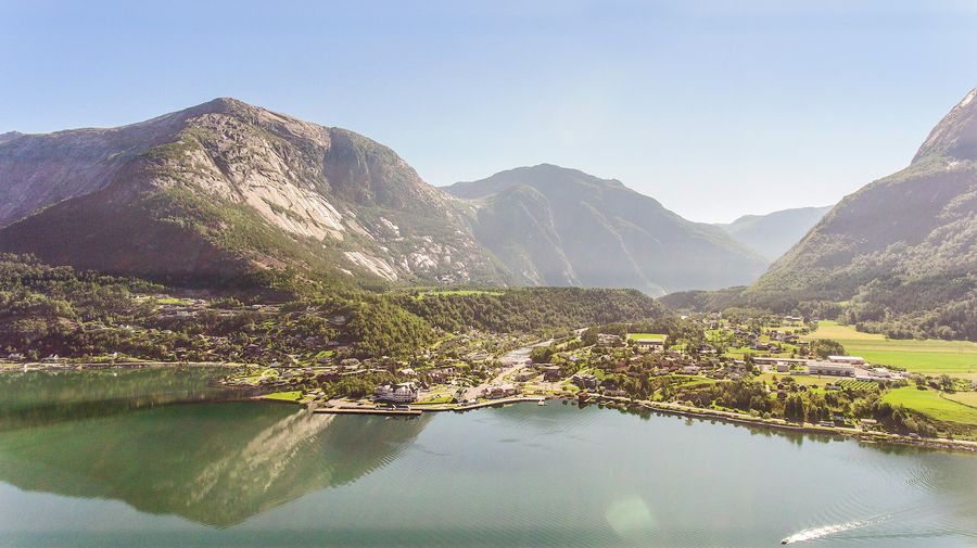
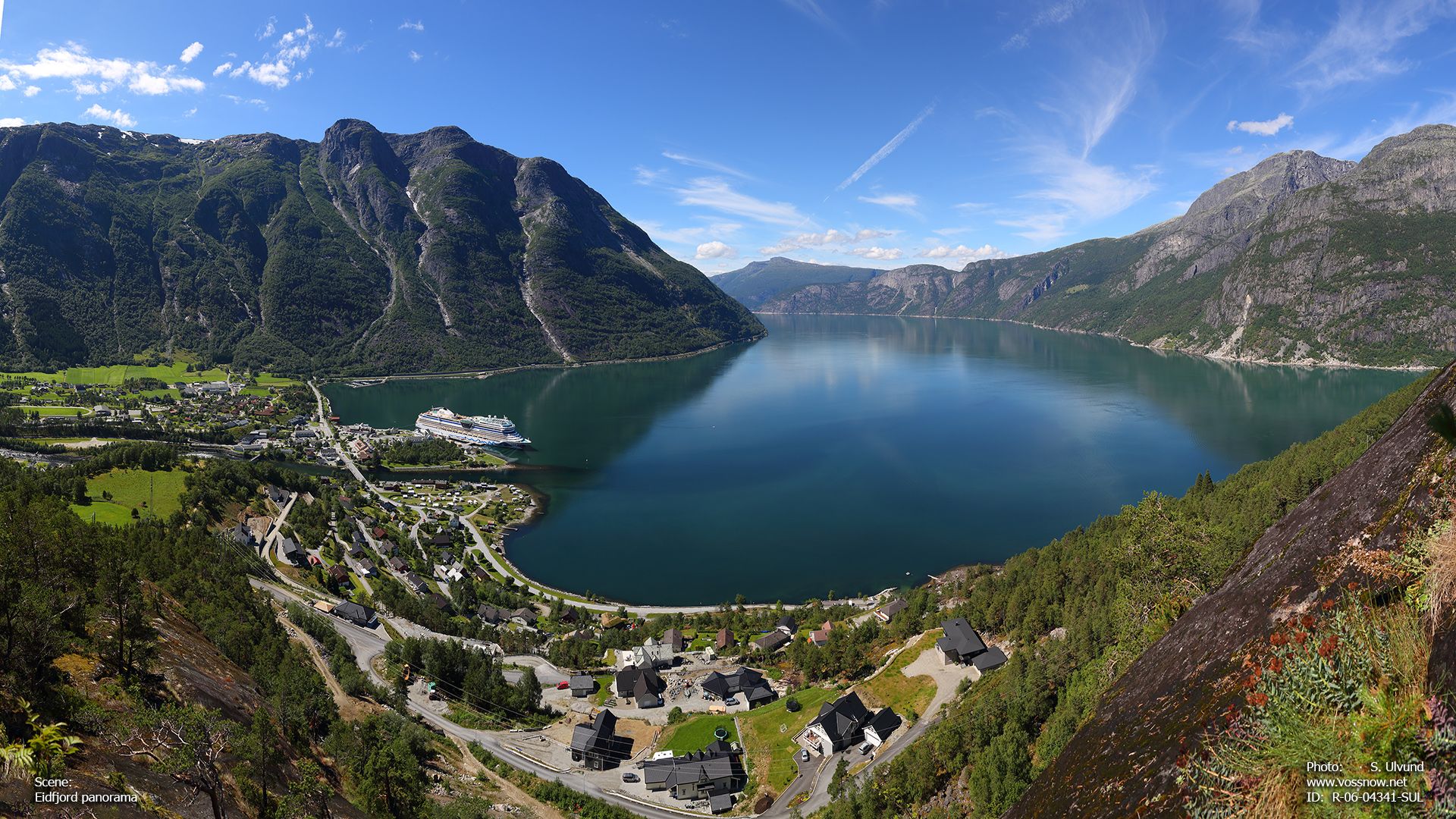
In some odd ways, the small town of Eidfjord is the most, and least touristy place we visited. With a wide, relatively flat valley and water supply, it's apparently a major supplier of apples and cherries. The town is so small that there is no rental office, and maybe a couple small shops and restaurants. Yet, you'll see leaflets posted at the tiny visitors center where people are renting out their private vehicles for a day or half-day. There's also tiny museum dedicated to a master violin maker, no pictures allowed, who's proprietor spends much of his time as a carpenter. The selection of measuring and precision planing instruments, nearly a century old - more in some cases - in-process blanks, and finished violins costing thousands of dollars (if they were on sale) are utterly fascinating. The inlay work was beautiful. The rest of the walk about the small town was quiet and relaxing, with a beautiful view of the rapids, and the interesting sight of houses with back-facing garage doors, and boat launch rails leading straight into the water.
More than anywhere else we'd seen, the landscape here was steep, nearly vertical cliffs, with tops rounded and sides scoured smooth by ice.
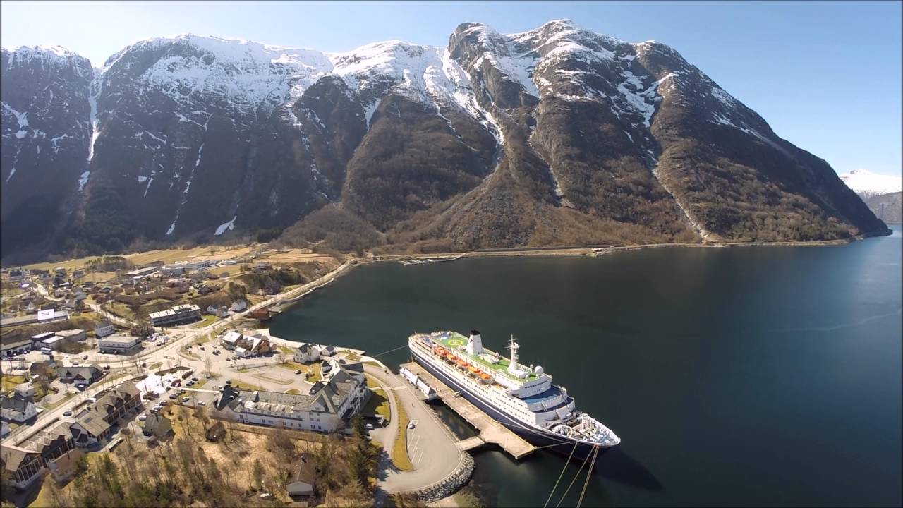
Kayaking was fun - nearly a mile from the town across the fjord to the far edge of the opening of the branch dead-ending at the power station built into the mountain, then up that fjord partway before turning back. I'm not sure what the depth was in the center, but the maximum depth of the Hardanger Fjord which Eid Fjord is a major branch of, is over 860 meters (over 2600 feet). We certainly had hundreds of feet under us.
I didn't take advantage of hiking opportunities, but the kayaking guide also did glacier hikes on the glacier, which was still supplying water visible trickling down the mountainsides. You can see evidence of ice/snowpack on the tops of the various mounts in the pictures, and we saw the same.
There is apparently an utterly insane iron man triathlon held there as well.
The Norseman xtreme triathlon is a non-Ironman branded triathlon, point to point, race held in Norway annually. The distances are equivalent to those of an Ironman race with the swim starting from the loading bay of a car ferry, through the water of the Hardangerfjord fjord to the local town, Eidfjord.[1] At Eidfjord the competitors transition onto their bikes and then cycle 180 km through the mountains, the first 40 km of which is uphill (reaching 1200 m above sea level).[1] After transition two (at Austbygda, 190 m above sea level), the competitors then run 42.2 km of which the first 25 km (to Rjukan) are flat and following this they end up climbing the local mountain, Gaustatoppen, 1,880 m above sea level.[1]
The race is "unsupported" so competitors need to have personal back up crews that follow them with cars to provide them with food and drink.[2] The support crews also have to accompany their competitor up the final mountain climb due to the inherent dangers of being highly fatigued on a mountain. During this final mountain climb competitors are required to carry a backpack containing emergency food and clothing[2] should the weather turn, whilst they are on the mountain.
Weather conditions and strict health checks and deadlines determine whether the race can be followed into the mountains and those that finish are given a black finishers top and take on the name "Norsemen". Those that do not make the cut-off time but complete the distance on a lower alternative route are given a white finishers top. The number of participants is usually limited to a certain number of competitors. Approximately 40% of the participants are from outside Norway; and about 15% are female.
More information on fjords here.
One footnote to the departure, as I hung out on the back deck to see and photograph the sights, I got to observe us clearing under the Hardanger bridge. Barely. On what is these days considered a small to mid size cruise ship compared to the humongous floating palaces out there.
The bridge is 1,400 metres (4,600 ft) long, with a main span of 1,310 metres (4,300 ft). Sailing height is 55 metres (180 ft) and the towers reach 200 metres (660 ft) above sea level. There are two driving lanes for cars with an 80 kilometres per hour (50 mph) speed limit, and a separate lane for pedestrians and cyclists.The sailing height means that the largest cruise ships can't reach the inner Hardangerfjord anymore.
The traffic predicted for the bridge was only estimated to be 2000 vehicles per day.The opening of the bridge took place on 17 August 2013.
The main span is one of the longest suspension bridge spans in the world.It is also the longest tunnel to tunnel suspension bridge in the world. On the south end of the bridge, cars immediately enter the 1.2-kilometre (0.75 mi) Bu Tunnel that goes under the village of Bu and on the north side of the bridge, cars immediately enter the 7.5-kilometre (4.7 mi) Vallavik Tunnel which includes a 500-metre (1,600 ft) long segment to a roundabout inside the tunnel. At the roundabout, cars can take another 500-metre (1,600 ft) long tunnel that leads to Ulvik or they can take a 7-kilometre (4.3 mi) long tunnel to Granvin.
Given how the bridge exits straight out of one rock wall midway and goes straight into the other - all but 90 meters of the bridge is the main span - with miles of tunnel on either end, I suspect that if the Norwegians had really wanted to, building the bridge a bit higher would have been feasible without a much greater financial cost.
In other words, they capped the size of the ships that could call at Eidfjord.
Also, as one of the longest suspension bridges in the world, it nevertheless has a bike and pedestrian lane.